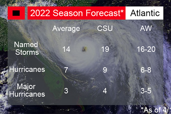
With less than 2 months before the start of the 2022 Atlantic Hurricane Season, seasoned forecasters have released their annual predictions on what we may be able to expect this year. Researchers and forecasters from Colorado State University, whose Tropical Meteorology Project is widely regarded as a leader in hurricane forecasting, and AccuWeather released their predictions earlier this month.
Both CSU and AccuWeather predict an above-average season for all 3 metrics (named storms, hurricanes, and major hurricanes).
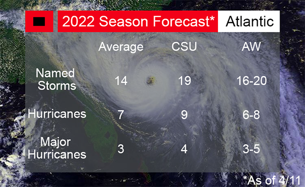
These predictions are based on several factors, including “Current weak La Niña conditions…while Caribbean and subtropical Atlantic sea surface temperatures are warmer than normal.” In addition to a predicted above-average number of storms, it is also predicted by CSU that there will be an above-average impact to US coastlines and their residents.
Agreeing with this prediction of above-average coastline impacts is Glenn Glazer, First Warning Meteorologist at WPBF 25 News. He crafted his prediction using a relatively new system of forecasting, the Lezak Recurring Cycle (LRC). But don’t let its newness fool you, it is also highly accurate. “In 2021, using this forecasting method, 75% of the storms that developed were correctly forecasted.”
Using this method, Glazer predicts that the #1 landfall hotspot in the 2022 Season will be the Florida Peninsula, both East and West coastlines. The second predicted hotspot is the Coastal Carolina area, and finally, areas on the Gulf Coast and in New England are listed as areas of interest.

These predictions are a stark reminder that in all hurricane-prone areas, it is important to be prepared for every hurricane season. These predictions are helpful tools for preparation, but as any Floridian can tell you, hurricanes and tropical storms can still make last-minute course and intensity changes that affect where they make landfall and what areas receive the worst damage. “Deanne Criswell, administrator of the Federal Emergency Management Agency, and Ken Graham, director of the National Hurricane Center, said they worried that many Floridians living in coastal communities had gotten complacent about making hurricane preparations since there hadn’t lived through major storms in recent years.”
For the last 2 years, the Atlantic Hurricane Season proved to be even more active than predicted. In 2020, several records were broken, including the most named storms in one season since tracking began. The 2021 season “…was the third most active year on record in terms of named storms, it marks the sixth consecutive above-normal Atlantic hurricane season, and this was the first time on record that two consecutive hurricane seasons exhausted the list of 21 storm names.”

It is highly active seasons like these that have prompted some changes within the National Hurricane Center (NHC), and led to consideration of other changes. 2021 marked the 7th year in a row that a named storm formed before the official June 1st start date of the Atlantic Hurricane Season. In response, last year officials decided to begin releasing official forecasting tools on May 15th.
Another change that some have pondered in the past few years is whether a Category 6 designation should be added to hurricane forecasting. The current hurricane measurement, the Saffir-Simpson Scale, maxes out at category 5, which describes any storm with sustained winds of 157mph+. Some argue, that because the scale uses intervals of around 20-25mph, a new designation for hurricanes of about 178mph or more should receive a designation of Category 6. There have been 18 such storms since 2010, including Hurricanes Irma and Dorian in 2017 and 2019 respectively.
However, this change is unlikely to happen officially anytime soon. When asked if a Category 6 designation would be added in the future, Feltgen said:
"NHC has tried to steer the focus toward the individual hazards, which include storm surge, wind, rainfall, tornadoes and rip currents, instead of the particular category of the storm, which only provides information about the hazard from wind. Category 5 on the Saffir-Simpson Hurricane Wind Scale already captures 'Catastrophic Damage' from wind, so it's not clear that there would be a need for another category even if storms were to get stronger.”
Even without an official category to designate these storms, researchers are trying to learn more about these kinds of storms and determine how we can be more prepared. In February of this year, the Florida International University (FIU) Extreme Events Institute received a $12.8 million agreement with the U.S. National Science Foundation to develop a testing facility capable of producing 200mph winds and storm conditions. This will allow the Institute to test these conditions against structures to determine what, if anything, needs to be done to protect Floridians and other vulnerable populations from these massive storms in the future.
Predictions and looking to the future are useful ways for us to better prepare for hurricanes. While we can’t know if a hurricane or tropical storm will make direct landfall until it occurs, it is never too early to start planning for a disaster and gathering supplies. Our comprehensive Hurricane Preparation Guide outlines all the information you will need to best protect your family during the upcoming season.
If you are trying to decide what kind of window and door protection is best for your home and property in the future, our Hurricane Shutters vs Impact Windows analysis provides helpful pros and cons for both forms of protection so you can make the best decision. For a free consultation on hurricane impact windows and doors, fill out our form or call 561-623-8446.

